Sandstone Way variations
Over the last few years I’ve got into the habit of heading of heading off on a fast packing/recce trip the moment the Autumn term ends. Late December isn’t perhaps the best time of year for wild-camping, but it seems to be an effective way of ‘resetting my head’ before Christmas. After a tough few months at work I wanted to do the same again this year, but the question was what/where. There was no upcoming race route that I needed to recce. I toyed with going back to the Pennine Way, but thought something new would be a better adventure. In the end I settled on a variation on the Sandstone Way, a 120 mile mountain biking route that runs South from Berwick-upon-Tweed to Hexham. There is a race along it which I’ve thought about doing, but it’s in October, right after the nightmare which is the start of term. From the outset I decided to cut some corners off the route. Partly because I needed to be back at work on Tuesday, and partly because there were some uninspiring looking road sections which could be by-passed along footpaths.
I’m normally pretty organised about packing kit, but I only got around to throwing stuff into a rucksack the night before. It turned out I had too much kit to fit comfortably into my UD Fastpack, so I ended up taking it (almost...) all out again and using my trusty big OMM pack. To minimise travel costs, while not committing myself to catching a specific train home, I bought a return to Newcastle and an advance single from Newcastle to Berwick. Which led to the slightly farcical situation of getting off one train to Berwick to get on the following train 15 minutes later. At this point I decided to get the map out to look at where I’d be going tomorrow. But I couldn’t find it. Where had I put it? I called the other-half: Me: “I’ve got a strange question for you. There’s a rucksack in the hall. Does it have a map in it?”. OH: “(rummages-around) yes there’s one which says “Sandstone Way” on the front”. Me: “F*!?... Well I do at least have the route on my GPS”. Except I didn’t. I hadn’t synced it properly. I spent the rest of the journey frantically trying to sync my GPS wirelessly and download TopoGPS maps onto my phone. Not the most relaxing start to the weekend... Eventually I got to the Youth Hostel in Berwick, and to my huge relief, discovered that they had Sandstone Way maps to buy.
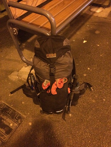
Rucksack (with no map in it...).
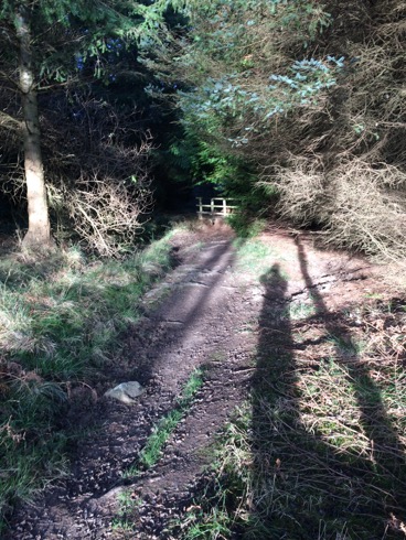
I set off at ~7 the next morning. I was planning on taking it fairly easy (and stopping for proper night’s sleep) but I’d have to put in fairly long days to get to Hexham by mid-afternoon on Monday. It was cold and sometimes icey underfoot. But the Sun came up to a gorgeous day. I’d often gazed out of train windows longingly at this stretch of coast, so it was great to run-walk my way along it. The Sandstone Way occasionally left the coast, but I stuck to the coastal path. This went fine until just after Holy Island, where I missed the turn inland and ended up scrambling along the side of a drainage ditch to get back on the path. After slightly nerve-wracking crossings of the East Coast Mainline and the A1 in quick succession, I followed the St. Cuthbert’s way through some through some picturesque woods and a rather excellent hermit’s cave (I quite fancied moving in...).
The rest of the day was a bit dull, lots of roads and sometimes muddy tracks. To cut milage I wasn’t planning to go into Wooler or Rotherbury, so my route wouldn’t pass through any towns other than Bellingham. I’d earmarked Chatton (which according to the map had a pub) as somewhere to stop and stock up on food, but the village shop had closed at midday and the pub was more of a hotel. Even if I could have brought myself to pay 15 quid for an overly poncey meal, I’m not sure they’d have wanted muddy, sweaty me as a customer... I did find a tap outside a closed cafe later on to top up my water bottles though. The next section, over a moor, was a bit more fun than the roads and tracks through farmland. I pondered stopping and camping there, but decided to press on a bit further, and tuck myself away in some woods for the night.
After another pre-dawn start I had to explain to a bemused dog walker what I was up to. And shortly afterwards a truck pulled up next to me on a lane. I was expecting a “what are you doing scaring my livestock” farmer’s rant, but quickly relaxed when I saw the driver was wearing an inov8 cap. It turned out he was a long-distance running coach, putting out markers for a race. We had a chat about ultra-running and he told me to stop in at a checkpoint up the road for a hot drink.
My deviation around Rothbury took me up onto the moors again. Which was good, apart from a minor nav mistake, which made me appreciate the usefulness of contours (the Sandstone Way map has none). This was followed by miles of dull, stoney forestry tracks, reminiscent of the Pennine Way before Byrness (unsurprisingly since it isn’t many miles away). I’d been looking forward to getting to West Woodbury, and hopefully stopping at the pub there for a meal. But things went a bit pear-shaped. First I decided to cut a corner off the route using a footpath. I picked my way across a rutted field only to be greeted by a 2nd field full of angry cows who didn’t want to let me pass. My next short-cut took me to a set of stepping stones, which were submerged under water, leading to a 2nd retreat.
Eventually I got to the pub. It had a sign saying “Good food served all day” outside, so I took my muddy boots off and went inside. It looked like a bit of a “localy” pub, so I was doubtful about the “good food” but any food would be fine. The woman behind the bar finished serving someone, walked off, and didn’t come back. I wandered into the restaurant bit next door and found a teenage waitress laying up tables. She was very friendly but told me that the kitchen wouldn’t in fact be opening for another hour (an interesting definition of “all day”). I needed to get to the Co-op in Bellingham before it stopped to buy food for the next day, so I decided to press on. As I put my muddy boots back on, some beered-up locals spilled out and offered me a lift to Bellingham... Which was kind but a little alarming.
In Bellingham I stocked up on pies, doughnuts and crisps, before heading to the nicest looking pub for a meal. The food was really good, but spicy stir-fried noodles aren’t the ideal running food and I couldn’t finish them. The pub meal made me soft, and I wondered if there was a bunk-house or hostel I could stay at for the night. According to the YHA web-site there a hostel and it had beds available for the night. I nearly booked online, but decided it would be easier just to turn up. So I did. And was greeted by a not particularly friendly woman who acted like I’d knocked on the door of a random house and told me they were in fact closed, and I couldn’t stay because they’d “been painting”. So I stomped off onto the moors and found a sheltered place to stop.
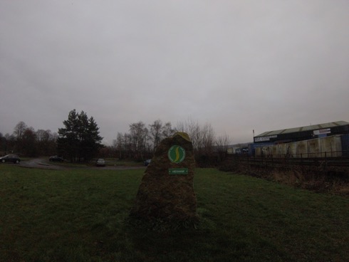
The first few miles the next morning overlapped, on and off, with the Pennine Way, which brought back (mostly fond...) memories. One of the local farmers had identified their sheep with metallic blue and purple paint, which made me smile. Less amusing was a closed bridge, which required a mile detour around it. To cut another small corner I decided to take a footpath across a farm. There were various signs saying the footpath had been diverted, but it wasn’t clear where to, so I marched across the field. At the other side 2 women asked me whether I’d got past the bulls OK... Apparently the footpath hadn’t been diverted at all and the farmer was trying to discourage walkers. The final few miles into Hexham were really dull, so I ran it to get it over with as soon as possible. The end of the route, on a patch of grass outside an industrial estate, was a little underwhelming:
It was a fun weekend, but large stretches of the route are a bit dull and I’m less keen on doing the race than I was before.