Escape from Meriden
So what route would I take, if I was going to do it? The LDWA web-page has an excellent searchable data-base of footpaths, but again footpaths tend not to be very straight. Google maps found me a fairly direct route on minor roads North from Meriden to Derby, and home (Chesterfield) is another ~20 mile North again... I was getting hooked. The problem would be getting home at the end of the 24 hours. I asked the OH if he’d be willing to pick me up from an unspecified location, somewhere North of Chesterfield at midnight. He agreed, and also offered to meet me somewhere along the way with resupplies of food and clothes. So the moment entries opened (literally...) I entered.
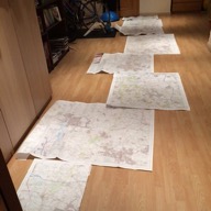
I bought cheap OS maps covering my route from Dash4it. Downloading and printing maps would have been cheaper. But I wanted to see my route laid out, and see if I could spot footpaths cutting corners which google maps had missed. It turns out the google maps route finding algorithm is pretty efficient, even for foot travel, and I couldn’t find any improvements. It wasn’t clear what the best route between Derby and Chesterfield was, there were several parallel options with similar distance. I’d planned to drive out and check them out one weekend but didn’t find/make the time to do it. I deliberately routed myself through Chesterfield, so I could stop at home and refuel. And after that I was going to take the trans-Pennine trail North towards Rotherham. I’m sure google maps would have found me a more optimal road route, but by that stage I thought I’d be glad to get off roads and onto familiar trails (my standard Sunday flat long route goes North on the trans-Pennine trail, with laps of Rother Valley Country Park, for mental toughness, in the middle). I wasn’t sure how far North I’d be able to get, but google maps found me some more minor roads (with pavements) running North from Rotherham towards Barnsley. I was unlikely to get beyond Barnsley, but (in a bout of last minute panic kit buying) bought a map which covered up to Wakefield and the Gold medal 90 mile ‘crow-flies’ distance, so that if I got that far I could ‘wing it’, rather than having to stop due to a lack of map. I marked the route on the OS maps and then (in what felt like an act of vandalism) cut them up and laminated them. I downloaded my route to the Suunto Ambit 3 that I’d bought in the aftermath of my navigation ‘issues’ at Trans Scania. I also bought a hand-held torch, with a red rear light, for added visibility when running along roads.
Race day came along and I realised I’d underestimated how challenging starting a race at midnight, at the end of a looong working week would be. I tried to have a nap in my office after my 4pm lecture, but in the end gave up and surfed the web until it was time to get the train to Birmingham. At Birmingham New Street station a pissed bloke (who turned out to be a decent runner) wanted to know what me and the handful of other people in lycra were off to do. I got to Birmingham International station just as a Jess Glynne gig was finishing, and had to fight my way through throngs of women charging in the opposite direction. The final stage of the journey was a bus-ride to Meriden, where various familiar faces assembled in the village hall.
At midnight we diverged in various directions. There seemed to be ~10 people heading on a similar route North, most in front of me (and, for reasons I didn’t understand, running with their backs to the oncoming traffic) and a handful behind. The first few hours went smoothly, a head torch behind kept closing on me, but never quite caught me. There were a surprising number of cars on the minor, pavement-less, roads. Some were driving fairly fast, so staying alert, and frequently jumping into verge was crucial. In the early hours it got really cold. I had plenty of clothes on (and more spare layers in my beloved Ultimate Direction PB 3.0 pack), but staying upright on the slippery roads and pavements was slow and tedious and I was feeling pretty tired and miserable. In Ashby-de-la Zouch I caught up with Mat and Joanne, who I discovered also live in Chesterfield. I stopped to eat some food and texted the OH, asking him to bring a sleeping bag to our rendez-vous North of Derby, so I could have a nap on the back seat of the car. (I didn’t realise he had his phone by the bed, just in case something went wrong and I needed him to pick me up, so I accidentally woke him up at 6am. Oops.) I was feeling sufficiently crap though that I was seriously contemplating just heading straight home with him.
As it got light the traffic got heavier, and also much worse at spotting me, so there was much more verge jumping. The worst bit was Swarkestone bridge over the River Trent. The road was really narrow, and even with my back pressed into the bridge wall cars were nearly clipping me, and the bridge was covered in debris from crashes. I was very glad to get across in one piece. Eventually I made it into Derby. It was a really Sunny morning, and I was rattling through my water supplies, but there were still icy patches in the shade. Because the OH was going to be resupplying me, I got sloppy with my kit. I finished all my water and got soaked in sweat, because I couldn’t be bothered to take my jacket off. And then I started to panic, what if he hadn’t made it to our meeting point, Little Eaton? We hadn’t fixed an exact spot, so when I reached Little Eaton I phoned him. It turned out he’d just that minute arrived and we were ~100m apart.
I changed into dry clothes and crawled into the sleeping bag on the back seat, having issued instructions to wake me up in 15 minutes. Despite being perfectly warm, I was shivering violently and didn’t sleep at all, but I did feel better for the rest. I then tried to eat some food. It took 10 minutes to get a small cheese and onion pasty down, with lots of retching (the OH kindly gave me a plastic bag, just in case...). After a longer than planned stop I headed North again, with the goal of running home at very least, and maybe keeping going to 60 ‘crow files’ miles and a Silver medal. The roads had wide cycle paths or pavements, it was a gorgeous day and I soon started feeling perkier. I’d even go as far as saying I was having fun... Until I encountered another hairy section, just North of Ripley, which made me wish I’d checked my route out in the car. I was on a B-road, which looked completely innocuous on a map. But in reality it was narrow, undulating and bendy, with lots of fast moving traffic and no verge to jump onto. I was very glad to reach Higham and the A61, which as well as being familiar running territory, is nice and straight with good pavements. I was now feeling good again, and dropped any thoughts of stopping at home.
To my surprise, and happiness, the OH was waiting outside having been watching my progress on the tracking site. To reduce the temptation of stopping I’d set up a mini-checkpoint, a table with gear on and a chair, in our hall. But in the end I decided it would be more comfy to sit in my usual place (on a pile of cushions on the floor in the sitting room) to eat my noodles. Which tasted so good I extended my stop to have a second lot. I changed into warmer gear for the 2nd night (including my knee length ‘spine pants’). I also switched from road shoes to my favourite Race Ultra 290s, which made me realise quite how knackered the cushioning in the road shoes was (they went in the bin the next day).
All told I was stopped for nearly an hour, but I felt a lot better for having got a lot of calories down and was now firmly set on keeping going until midnight. About half a mile from home I realised I was missing my water bottle. I’d given it to the OH to refill along with my bladder, but in the faff of reclosing the bladder the water bottle had got left in the kitchen (and I hadn’t spotted it when doing my ‘am I leaving any kit behind’ check). I couldn’t face going back again, so rang the OH and he drove it out to me.
The one down-side of running along one of my regular routes was that I was going to be moving far slower than usual. But I’d steeled myself for this and it wasn’t too tough mentally. In fact time was moving a lot faster than during the first night and I quite enjoyed reaching Rother Valley County Park and running part of the Round Rotherham 50 route in reverse. On reaching Rotherham I decided to leave the Trans Pennine Trail earlier than planned: running along a derelict tow path in an urban area late at night didn’t seem like a great idea. Through the city centre I improvised my route to avoid the rowdiest clubs/bars, slowed to a walk & turned my head torch off to avoid drawing attention to myself.
North of Rotherham the road undulated, so I walked a fair bit, but it always had a decent pavement. I was now in the last hour and in a win-win situation. If I looked at my watch and it was later than I thought, that meant I was closer to stopping, but if it was earlier I had more time to cover more distance. I didn’t spot the OH drive past in his car, but at 23.45 a familiar figure emerged from a side-road. I wasn’t ready to stop quite yet though, and had already ear-marked a pub a mile or so down the road as my goal. So I crossed the road, told him the plan, crossed back and plodded off again.
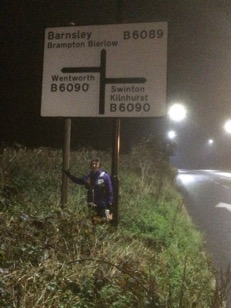
I got to the pub a couple of minutes before midnight, but was now happy to stop. I clambered through some undergrowth and posed for photos under a road sign, before jumping into the car for the, much faster, journey home. I made it 72.7 miles as the crow flies (and covered 82.9 actual miles). It was a couple of miles less than I’d hoped, but given how I struggled through the first night I was satisfied. And surprised to discover that it was enough to place me 10th overall out of 71 individuals/pairs and first woman (just, 2nd place was only a couple of miles ‘behind’ having taken a much hillier route).