Trans Scania tips for foreigners
Trans Scania is a small (~20 participants) 246km (153 mile) trail race across the South of Sweden (from the West coast to the East Coast and then most of the way back). It’s really well organised, but the only support during the race is a single drop-bag accessed at ~43 and ~116 miles. You can have a support crew if you want, but in 2016 most of the runners appeared not to. I’ve blogged about my experience of doing the race (and getting lost lots...) elsewhere. Here are some, hopefully useful, tips for non-Swedes doing the race in future:
1) Navigation
The maps are 1:50k scale and parts of the route wind through dense forests with multiple paths. The route is marked, but the markers aren’t directional and often aren’t in the most useful places (and on a couple of occasions appeared to do confusing things).
Unless you’ve got yoda-like navigation skills, having the route on a gps device will make your life a lot easier (and your run a lot faster). I’m usually an OK navigator. On a race like this I’d usually make a handful of mistakes, the vast majority of which would only cost me a couple of minutes. I don’t have enough digits to count the number of nav errors I made at Trans Scania. And lots of them were time-consuming (and distance adding). I’m guessing I possibly wasted 2 or 3 hours.
2) Food supplies
Check out the race Facebook page for locations and opening hours of supermarkets, cafes and water taps. They’re frequent enough that you don’t need to carry huge amounts of supplies, but rare enough that you need to plan. The most common supermarket (both in Sweden and on the race route) is ICA. It’s worth having a look around one in advance to see what they stock (there’s an ICA just outside the train station in Lund). There’s less ‘portable vegetarian running junk food’ than in the UK, IMHO. No cheese and onion pasties (one of my favourite multi-day running foods), but I wish British supermarkets sold drinking yogurt (lot of easy to consume calories).
3) Equipment: footwear & head torch
I’d suggest moderately (but not super) grippy, cushioned trail shoes. There’s a significant amount of road/hard track, but also some short, sharp ascents/descents on small stones/grit, and a lot of rutted/rooty paths. There are some field crossings. I can’t imagine they’d ever get as muddy as British field paths do. But if it rains lots in the run up, it’d be worth getting some local advice about underfoot conditions. I used Inov8 Race Ultra 290s and was happy with them (for reference I usually run UK canal tow path races in road shoes).
A head torch with variable brightness is useful, so you can up it a bit on technical sections and a lot when looking for trail markers. I used a Petzl Myo RXP, and again was happy with it (I don’t think something with a brighter max would have made looking for route markers in the dark any easier).
4) Wildlife
There’s lots. I saw (and hurdled...) my first ‘wild’ snake (it was a very small one though). The cattle don’t seem particularly aggressive. I wouldn’t suggest trying to run through them. But, in my experience, even the herds with a bull in, can easily be walked around or, if necessary, shooed off the path. On the other-hand wild boar (who aren’t used to humans coming through their home at night) should be given a wide berth...
5) Electric fences
There are lots of them, they’re live and give you a hefty kick if you touch them for too long. However if you think you need to climb one, something has gone wrong. Some of them have rubber handles and hooks which allow you to lift the top wire and step over the bottom one. Others have hidden squeeze routes around the sides.
6) Pacing
I probably shouldn’t make sweeping generalisations about nationalities on the basis of my personal experience of two Swedish ultras. But I will. Swedes are, on the whole, much, much better at pacing than Brits. In a 100+ mile race in Britain I’d expect to be off the back of the pack for the first ~20 miles, and then slowly work my way up to mid-field (on a good day at least...). At Trans Scania, despite running even more slowly than usual, there were a handful of people not far ahead of me for the first few hours. And even if I’d been fit, I wouldn’t have been able to run/walk at as close to even pace as most of the rest of the field.
7) Logistics
The easiest place to fly into is Copenhagen. There are regular trains to Lund, taking ~45 minutes (a bit more in the incoming direction due to passport checks, a bit less in the opposite direction). Hotel Lundia, is right next to the finish, close to the train station, reasonably priced and very Scandinavian. In Copenhagen, CabinInn Metro is very basic, but cheap and conveniently located (close to the train line for Lund and 2 stops from the airport).
Check-in and security at Copenhagen airport are (as with most Nordic things) remarkably efficient, and there are some decent shops in departures. Including a Lego shop with an excellent selection of Star Wars lego...

Trans Scania
I discovered Trans Scania in 2015, when I was looking for a late Summer long run to ward off the post Thames Ring blues. In the end I decided to enter the Liverpool Leeds Canal Race instead. But I added Trans Scania to my running ‘to do’ list. When entries for 2016 opened in October they started filling up quickly. So, in an uncharacteristic act of spontaneity, I entered. It would be my 3rd long race of 2016 (after the Viking Way and the Northern Traverse), but they were well spread out, so I thought it would work OK.
Not long after that things started going wrong. A fall when fell running, which led to a dislocated (and permanently damaged) finger, kicked off six months when nothing went right. I crammed too much training into too short a period of time for the Viking Way. My knees objected and, after 90 of the most uncomfortable miles I’ve ever run, I DNFed the Viking Way. I didn’t do much running between the VW and the Northern Traverse in early June, in the hope that my knees would recover. However the NT was sufficiently hilly (and boggy) that I managed a decent finish by walking most of it (and not sleeping much). And my knees felt better on day 4 than they did at the start. Trans Scania would be a different beast though. I’m not a fast enough walker to walk it in the 60 hour time limit, so I’d need to do more running. I only booked my flight and hotels (and mentally committed to it) in early July after the OH convinced me that if I wasn’t up to running, I could have a short holiday in Sweden.
Through July and August I managed a few long runs (including a 38 mile elephant hunt...), but nothing I’d describe as proper training. My knees weren’t painful, but they were stiff and sore, which made running slow and not much fun. I felt strangely laid back about Trans Scania though. I guess there was no point worrying. While the time-limit wasn’t walkable it was generous enough that if I could keep moving I should be able to finish. And looking at the 2015 results, a ~50 hour finish would hopefully be doable.
Normally my race blogs start with me complaining about being busy/stressed at work, and looking forward to the race as a holiday. But this time was the complete opposite. It was mid-Summer and I’d cleared (or deferred...) the pointless admin crap and was focussing on research, and enjoying myself. I almost wished I could spend the weekend carrying on with my calculations rather than running.
Preparation
Since there would sometimes be a long gap between water sources I decided to use the Ultimate Direction PB 3.0 pack I bought for the Northern Traverse, with a 2 litre bladder (which I’d mostly only partly fill) and a 0.6l bottle. For food I took ~100 calories per hour of my usual running foods (gels, Hula hoops, Mars Bars, Ritz crackers and cold Dominos pizza) and planned to top this up at supermarkets en route.
I bought the recommended maps and highlighted the route (and the deviations at Lövestad and Brösarp) on them. I usually prefer to navigate using a map rather than a GPS (I’ve used a hand-held GPS occasionally on the Spine and the Northern Traverse, but that’s all). I realised that navigating woods using a 1:50, 000 map might be tricky though. So I uploaded the route to my (aging 1st generation) Suunto Ambit and practised using the navigation feature on some of my regular training routes. Also, as a back-up, I downloaded the Topo GPS app recommended by the organisers and bought a couple of power banks for recharging my phone.
The ‘race’
I flew into Copenhagen the morning before the race, so I could get to Lund in time for the pre-race dinner. The dinner was in a somewhat fancy Thai restaurant next to the finish, and also the hotel I was staying in. Not what I’d usually eat the night before a long run, but very tasty. Dinner was early, so I had time to catch up on some work emails before taping my knees, sorting my gear and sleeping.
Taxis took us to the race start at Långa Bryggan, which was indeed a very long bridge. After a low key start, almost everyone walked back along the bridge. I’d already decided that I would walk, to avoid starting the race by tripping and falling in the sea, but I was surprised to have so much company. And even along the roads back to Lund the field didn’t spread out too much. I was at the back most of the way, but there was usually someone in sight in front. At one point I initially missed the route turning off a road onto a footpath (because the thick red line which marked the route made it hard to see what was going on beneath). It didn’t take me long to spot my mistake and correct it, but it was the first sign of what was to come. I wasn’t the only person making mistakes though, there were a couple of runners who overtook me several times, despite me never passing them.
One of the race organisers, Magnus, accompanied us to the start of the Skåneleden trail (which the race would follow) at Skryllegården. We chatted for a bit, and the conversation turned to Physics and we discovered we had a mutual old friend/aquaintance in the form of Max Tegmark. I got to Skryllegården at ~15 miles in about 3.5 hours. A fair bit slower than I’d usually cover that distance, but there were a handful of other runners eating, refilling water bottles and in one case taping chafing. I refilled my water bottle and bladder and set off again fairly quickly. There were several parallel paths and it wasn’t clear which was the right one. I initially took the wrong one, but with the help of the GPS route on my watch soon got myself onto the right path. My suspicion that the map wasn’t high enough resolution to navigate through woods was confirmed, and eventually I got to grips with navigating through the woods using the route on my watch and the yellow markers on trees. I suspected that the watch battery wouldn’t last for the whole race, but hopefully it would get me through to the turn around point at least.
The route was proving a bit harder for me to run than I was expecting, there were a few very short but steep ascents and descents and some over-grown field edge paths. I got to Blentarp, the first place with a shop, at 38 miles at 17.30. A bit later than I’d hoped/expected, but not too much. I stopped at the shop and bought some drinking yogurt, a doughnut and some bread which I ate outside. Over the next few miles, towards the drop bags just outside Sövde, I kept seeing Lena walking at a fast pace in front of me carrying a bag. Whenever the ground under-foot was smooth and runnable, I started to close the gap, but when it got more uneven she pulled away again. I finally caught her at the drop bags, where she told me that her son had messaged her to say that the local radio had reported on the fact that she was outside the shop in Blentarp resting while I bough sweets inside!
I spent about 30 minutes at the drop bags, eating, restocking food and adding some warm layers to my pack for the night. Lena and I left at the same time, but she soon pulled ahead. It began to get dark surprisingly quickly and the drizzle that had been falling for a little while turned to rain. And then, without warning, my watch turned itself off! I knew the battery was going to run out at some point but I hadn’t expected it to happen so soon (in the past, without using the navigation feature it’s lasted 60 hours). And for a brief second I felt terrified. How was I going to navigate my way though the forest, in the dark and rain, on my own with only a useless map? (At this point Lena was still just visible in the distance, but I knew I’d struggle to keep pace with her, and blindly following someone else would’ve been wrong even if it had been possible.) I quickly calmed myself down. I had the route on my phone. Using it all the time would quickly run the battery down. But I had a recharger for the phone (plus another in my drop bag) so I could use it when I really needed it. And in the meantime I resolved to carefully watch out for the route markers, and back track if I didn’t see one for a while.
Initially this went OK, although at one point I wasted a lot of time going back and forth when I was in fact on the right track all along (and metres away from the next route marker). Running along a gravel farm track I spotted a small snake, seconds before I was about to tread on it. I managed to jump over it instead. I’m scared of snakes, and had never seen one in the wild before, but it didn’t bother me as much as I would have guessed it would. I made a few small mistakes when I failed to spot kinks in the route which weren’t visible underneath the thick red route line (although in one cases, judging by the footsteps in the grass, I wasn’t the only person who’d had to wander around at random to find the route).
I’d marked the route and the deviations into Lövestad and Brösarp with a highlighter pen. The map was waterproof, but the highlighter wasn’t. Once I noticed I put the map back in it’s plastic cover, but not before the rain had erased the route deviation into Lövestad. I remembered that it involved a road, so when the Skåneleden turned off the road to Lövestad I initially carried on running down the road, making the most of the flat, even surface. And then I remembered that the instructions also involved a windmill, and I couldn’t see any windmills. So I stopped, got my phone out and downloaded the race instructions. Our deviation was a bit further along the route, and I was cutting a corner, so I back-tracked back onto the trail. I passed a runner sat on a bench outside a farm. He didn’t seem very happy, and I didn’t see him again, so I guess he dropped.
I eventually made it to Lövestad. I’d heard a lot beforehand about how the locals supported the race. The supermarket closed at 8pm, but apparently the owners would sit in the bar opposite, looking out for runners coming through and open the shop for them. By the time I got there after midnight even the bar was closed. So I sat on a piece of sheltered concrete and ate some of my cold pizza.
I wasted a lot of time wandering around a single field just after Lövestad. The map and my phone both agreed that I needed to turn left, but I couldn’t find any more route markers or a way out of the field. Eventually I found the route next to a fence which started in the middle of the field. And then it hit an electric fence beyond which there was a ~2 metre wide gap between two fences which seemed to be completely overgrown. I tried to the right, nothing. I then tried to the left, and found a faint path. But I could see route markers in the overgrown grass between the two fences, so that was the route. I was only a metre off route, but separated from it by a crotch high electric fence. After some gymnastics, and one shock, I managed to get over the fence and back on track.
A bit later I struggled to stay on route as it meandered through some fields with sparse trees. The route markers were few and far between and not all of the wiggles were big enough to show up on the map. Eventually, I decided that walking with my phone in my hand, was faster than repeatedly going off route and having to get it out to get back on course. It made me nervous though, If I dropped the phone and broke it, not only would it be expensive to replace/repair, but I’d be left with no way of navigating through the woods.
Eventually I made it on to some easier to navigate, and run, tracks. Jogging along I heard some high pitched screeching, and saw some small, barrel shaped animals darting around in the bushes on both sides. Luckily Magnus had warned me about the wild boars (and in particular the females being protective of their young), so I hung back until they disappeared. Just before Christinehof I met the two leaders coming back. They were moving fast, but still stopped for a quick chat. They seemed surprised that I was navigating using a paper map and warned me that the next section was tricky. And it was. The route wound through an over-grown forest, through nettles and over downed trees. I only went off course once though and spotted it and got back on track quickly.
Some meandering tracks followed, and I found it hard to keep on top of where I was. Richard (who’d actually been behind me for some of the opening miles) came past in 3rd place. The route briefly went along a road and I overshot a barely visible turn back into fields. Missing the turn was understandable, but I ran significantly further along the road than I should have done before I realised and turned around. Having not refilled my water bottle at either Lövestad (everything was closed...) or Christinehof (the precise location of the tap wasn’t marked and I didn’t spot any signs) I was running low on water and rationing it. In the end I decided to take a risk and refill it from a stream (something I usually avoid doing in low level farm land). As dawn came a string of runners passed in the other direction.
With the Sun up the navigation became a lot easier and I made my way through Brösarp and towards the turn-around at Haväng without any more mishaps. A bunch more runners passed me in the final couple of miles, an hour or so ahead of me. In the UK I’d have been thinking about reeling them in the second half. But the Swedes are better at pacing than the Brits, plus my lack of fitness/training was starting to catch up with me. However I hoped that having seen the route (albeit in the opposite direction) I would loose less time to navigation issues and not slow down too much. Ha ha!
The last runner I saw was Peter, who emerged from the Youth Hostel as I headed down to the beach. I didn’t linger at the turn-around point and headed back to the Youth Hostel to sort myself out. The first thing I did was take my socks off, and had a nasty surprise. The pads of my toes had been hurting, but I’d put that down to gripping too hard on steep slopes, and I wasn’t expecting to have any foot problems. However what I found was the 2nd worse case of maceration I’ve ever had. The worst case ended up with blisters all over the soles and sides of both feet and left me barely able to walk for weeks. So I needed to take some urgent action if I wanted to finish the race. I dried my feet off, and left them uncovered while I ate, rearranged my food supplies, changed the batteries in my head torch, recharged my phone and texted the OH (I hadn’t heard from him since Thursday night and mild irritation was beginning to turn into worry). This took about 20 minutes, after which I recoated my feet with sudocrem, put on a clean, dry pair of socks and got moving, slowly, again.
I stopped at the supermarket in Brösarp for more yogurt and bread, plus some nectarines (they don’t have a high calorie density, but are a nice treat). When I arrived Peter was outside eating. By the time I came out he’d gone, so I was surprised when he reappeared and suggested that we walk together. I guess he’d had trouble finding his way back on to the Skåneleden. When we reached the long straight road after Brösarp, I explained where the turn would be and said I’d like to run for a bit. I expected he was going to drop back but instead he started running too, but far faster than me. He stopped at the turn and we both discarded layers before run/walking together for a while. I was struggling to run anything which wasn’t pancake flat and perfectly even, and every time I stopped to walk Peter would too. We passed Zingo going in the other direction. He’d stopped to sleep, and was worried that he wouldn’t be able to finish within the time limit. I’d been needing a poo for a while so I stopped at a really rather nice outdoor toilet I’d spotted on the outwards journey. When I came out Peter was sat down and said that he felt very tired and was going to stop and rest. I told him that a 10 minute power nap would make him feel much better. I was happy to be back on my own though. I’m an antisocial runner, particularly when I’m not feeling great.
The next stretch was, unsurprisingly, easier to navigate in the daylight and I made it back to the wiggly woods without any problems. But here things went very wrong. I was managing to follow the route markers fine. After a while our yellow markers were joined by blue markers, which I assumed just meant that another, blue, route was overlapping ours at this point. The way (it certainly wasn’t a path) was more over-grown and scrambly than I remembered, but I was following the markers, so it had to be right. And then it ground to a halt at a fence. I got my phone out and discovered that I was way off route. I was a bit nervous about back-tracking through the dense forest (and worried about getting completely lost). However with a combination of memory, the GPS and the route markers I made my way back to the point where the yellow and blue markers reverted back to yellow only. And initially started going back along the route in the wrong direction... I kept my phone in my hand, and checked it regularly, until I, finally, escaped from the woods.
The meandering section which had caused me problems the night before was fine in the daylight. Along the way I passed Peter (who’d obviously passed me when I was on my random walk around the wiggly forest) sat at a bench with his head down. I didn’t say anything as he was obviously trying to sleep. The easier tracks gave me some time to think, and I solved the problem of the missing OH. Had he been sending me iMessages which weren’t getting through? I got my phone out and typed a quick text message: “are you sending iMessages? If so they won’t arrive (because there’s no wifi in forests).” And got an instant reply. Problem solved...
Another mystery was solved later on, at the overgrown path which had appeared to be fenced off (which led to electric fence gymnastics). In the opposite direction, in the daylight, there was a gap visible on one side of the fence to pass through. I made it back to Lövestad by early afternoon and stopped and bought yet more drinking yogurt, bread and nectarines. I sat on the concrete opposite again and got my feet out for an inspection. They were a lot better than at the turn around point, but there were still several patches of maceration. So I sat and ate while they dried off for 20 minutes.
The roads and tracks after Lövestad were straight-forward to navigate in the daylight, and I even got a bit bored, so I got my iPod out and stuck it on shuffle. This was a bad idea. Shortly after, slightly distracted, I made a really silly navigation error. I thought I knew where I was, and took a right turn without looking at the map. Five minutes later I realised I hadn’t seen any route markers since the junction. So I back-tracked to the junction, checked my map and phone, and discovered that I should have turned left.
Listening to music also triggered an ear-worm which lasted for the rest of the race (curiously it wasn’t on my iPod): “Marlene, Marlene. Your eyes sparkle while your diamonds shine”. Even more frustratingly I couldn’t work out what it was. Googling the lyrics was one of the first things I did after checking in to the hotel at the end of the race. It turned out to be an obscure Transvision Vamp album track, “Falling for a goldmine”.
Annoyingly darkness came just before I hit another fiddly forest section around Snogeholm, with multiple overlapping tracks. This was where my GPS watch had died at dusk the night before. I’d made it through then fine, but in the opposite direction it was a different story. I was carefully following the yellow markers. A turn I was looking out for was taking longer to appear than I thought it should. But maybe I was just moving slowly. I was following the yellow markers, so I had to be ‘on route’ (I hadn’t learnt my lesson from the route markers in the wiggly woods earlier...). Eventually I got my phone out and discovered I’d in fact gone several hundred metres past the turn. I later worked out that on this section, ‘our’ yellow markers were a slightly different shade of yellow, with a dark brown/black background. I decided to play it safe and do the rest of this section with my phone in hand. There was a strange wiggle in the GPS track. I dutifully followed it, off the main track to a wooden shelter. I was feeling a bit sleepy, but I decided to push on to the drop-bags, which weren’t far away (and where I’d have extra clothes to keep me warm). Getting back onto the main track was a bit fiddly, even with my phone in my hand.
I eventually made it back to the drop-bags. I didn’t feel too sleepy and could have kept going. But given the navigation issues I was having (and the fact there were another 6 or 7 hours of darkness ahead of me) I decided a 45 minute sleep would be a good idea (and the idea of sleeping until dawn and then setting off in the day-light even briefly crossed my mind). I changed into dry clothes, put some extra layers on top, set my alarm, stuck my bare feet in my dirty washing bin bag (so they’d stay warm while airing) and lay down with my head on my drop bag. It was a bit cold and uncomfortable, but I got some decent sleep, which made me feel better. In every day life I often struggle to get to sleep, because I can’t stop thinking. But here thoughts were coming into my head at such a rate that I couldn’t do anything but let them stream straight through.
At some point I came across a herd of cattle on a track. There was no way around them so I had to go through. Initially I was quite blasé (“I grew up on a farm, I can cope with cows”). And then I spotted the bull... I walked slowly, gently shooing them out of my way and eventually got through. The bull seemed to actually be a calming influence, at least it looked like it was keeping the flightier cows under control. The next field had another herd, sleeping with calves. After a failed attempt at going through, I went around this lot.
Just before Dörrod golf course there was another short wooded section, which had been fine in the daylight, but was tricky at night. I stopped at a shelter to eat some pizza and top my water up, and discovered some luxurious, heated toilets! Just after the golf course there was another over-grown forest section. Despite looking out carefully for the turn-off I marched past it and up the road. I was really tempted to just keep going, the road wouldn’t just be a lot quicker but also significantly shorter. (I usually prefer trails to roads, but I was beginning to get annoyed with the route. Why fight your way through an overgrown forest when there’s a perfectly good, quiet road which goes where you want to go, faster?). It took a lot of will-power to turn around and back-track. It turned out I’d missed the turn off because there actually wasn’t a gap in the fence. Instead there were small route markers at ground level and a section of the electric fence could be lifted up. I kept drifting off the route in the woods, and this ended up being another ‘phone in hand’ section.
Dawn came and I was feeling a bit sleepy, so I sat down for a 5 minute power nap in what appeared to be a very deluxe bus shelter. The next section went through some forest, where shelters had occasionally been built out of branches. And I started ‘seeing’ shelters self-assembling in trees, which was a bit disconcerting. So I sat down for another 10 minute power nap which woke me (and the small furry creature whose home I sat on) up. I got slightly frustrated when it seemed like the route was taking me around 3 of the 4 sides of a square field. Looking at the map afterwards, it didn’t really, although going straight across the field would have been more direct.
The next few miles dragged. The terrain underfoot was too uneven for me to try and run when tired, and I was even struggling to manage to eat and walk at the same time, so I stopped and sat on a rock to get some calories down. There was then a stretch of tracks and road which were faster going. But I got really frustrated when the route cut away from the road to take in some over-grown, rutted field edge paths. Eventually signposts for Skryllegården started appearing, but the distance didn’t always decrease monotonically.
Most of the route is very rural and, outside of the towns, I hadn’t seen many people. But as Lund came closer there were lots of people out walking and running. Fortunately I wasn’t overtaken by any walkers (that has happened in the past...) but it was a bit depressing how easily the runners were gliding past me. A woman, who obviously knew about the race, offered me tea or coffee, and I felt bad declining (explaining that I couldn’t have any because I was running unsupported). Despite living in Stockholm for two years I can’t speak Swedish, however I can understand basic Swedish. So I had several short conversations where the other person would ask questions about what I was doing in Swedish and I’d respond in English.
The final wooded section seemed far longer than it had on the way out. When I eventually got to Skryllegården I sat down (for a bit longer than was probably necessary...), ate and texted the OH to revise my estimated finishing time. The last 8 or 9 miles back to Lund were fairly runnable. And I did run most of them, but still it took a long time. And even though the end was close I kept having to eat, because if I went more than 30 minutes without eating I started feeling sick. I stopped at the edge of Lund to phone Magnus, one of the organisers, and let him know I was close to finishing. We’d been given a map with the last mile or so in a series of high resolution panels, and I ticked them off one by one. Discovering that the last two panels overlapped significantly and I had less distance left than I thought made me very happy. Weaving around people and trying to run on uneven cobbles made me less happy. I turned the corner, past Henrik (who’d finished more than half a day before) in a bar, and tried to run properly into the finish.
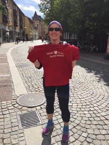
Magnus was there waiting with a handful of earlier finishers. One had finished an hour before, but the others had had a good night’s sleep in the meantime! Luckily (especially for the people who had to sit near me on the train to Copenhagen) there was a room at the finish where I could have a quick shower. When I came out Peter had finished, not long behind me. Given how miserable he was when I’d last seen him (more than 24 hours before...) I was happy to see he’d kept going. I phoned the OH, shared race stories with some other finishers and then headed off to the train station.
Post-mortem
I was much, much slower (4 or 5 hours) than I’d hoped. I’m guessing about half of this was due to my navigation ‘issues’. I usually like to think of myself as a decent navigator; not brilliant, but definitely not awful either. However I think I made more mistakes in one weekend than in the entire rest of my life! Some of the wiggles in the route just weren’t visible on a 1:50k map (and sometimes they were, but I didn’t look carefully enough to see them at the time). Plus it took me a while to get to grips with what was and wasn’t marked on the map and how. It didn’t help that the route was marked with a thick red line, which made it hard to see what was underneath (road, track or path) and key junctions were sometimes covered by symbols. Ultimately I think the map wasn’t the best tool for navigating this route.
My various ‘niggles’ and lack of consistent training this year obviously slowed me down a bit down too. But I still don’t understand quite how/why I was so slow during the 2nd half. I’ve been that slow before, but only when I’ve been physically (my 1st two 100s) or mentally (T184) broken. Here, however, I was still running a large fraction of the runnable terrain but my running was slower than most people’s walking pace... Maybe I could have finished an hour or so faster, if I hadn’t stopped to sleep and air my feet. But it wouldn’t have been worth the risk of wasting even more time getting lost while sleep-deprived or my feet blistering so I couldn’t run at all. Looking on the bright-side, at least I didn’t give up mentally and walk it in like I did two years ago at T184.
I’ve managed to run two long events in Summer, with most of the focussed training before the first, successfully in the past. However this was my 3rd long one of 2016. Maybe it would have worked if life hadn’t thrown me so many curve-balls. But as it was I haven’t done back-to-back long runs (which are the staple of my training for 100+ mile events) since March. If running as well as possible was my priority I’d have pulled out of the Viking Way, the Northern Traverse and Trans Scania when the knee problems started in March. However I’m pretty sure I feel happier for having given them a shot. And a mid-field finish at the Northern Traverse (albeit through sleeping less than most other people) and a finish at Trans Scania isn’t a bad year. Just not as good as the past couple, where I kept surprising myself by doing things I thought I wasn’t capable of (finishing the Spine and being close to the front of the field at the Thames Ring).
It’s time to regroup now though. No more super long races this year (I had been fancying the Sandstone Way in October but, thankfully, work commitments have ruled that out). The priority now is to get the niggles sorted (physio appointment booked for next week) and then start building the training up, slowly and consistently, for next year’s Viking Way.
As far as Trans Scania goes, I’ve got unfinished business. Normally I’m a long event box ticker. Rather than going back to events and trying to go a bit faster, I prefer to try new things. Which I think is sensible; I run best when I don’t focus on finishing time or position, and with long ultras various things (weather, stomach problems, feet problems...) can screw up the best laid plans. However I’m not satisfied with the tick I’ve put in the Trans Scania box. The route really doesn’t suit my run-walk-shuffle, but I really should be able to do it in ~48 hours. So I will be back. Not in 2017 (I’ve just entered the Last Annual Vol State 500), but hopefully in the next couple of years. And I’ve got my eye on a Suunto Ambit 3 Peak with super long battery life...