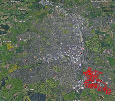
Streets of Chesterfield
I'm usually fairly analytical and unemotional about running. But there's something about Rickey Gates' writing about running which really resonates with me. His trail runner article about his TransCon run made me so wistful for my own, much shorter, journey runs that I nearly cried. And a TransCon (journey run style rather than as fast as possible) is now firmly on my to do list for when I retire. So it's not surprising that reading about his Every Single Street project inspired me to do something similar in Chesterfield, the much smaller town where I live. It also seemed like a good way of ramping my milage back up post injury.
My initial plan was that I'd stick to my usual long weekend runs on the Transpennine trail, but spend my weekday evening doing increasing long runs around Chesterfield. Chesterfield might be much smaller than San Francisco, but I quickly realised that it was still going to be a significant project. One evening I set out to 'do' Hasland, the area were we live. An hour later I'd done a single housing estate, and was cursing its planners for its rabbit warren like layout. The cul de sac out-and-backs were annoying enough. But even worse were the networks of roads where it wasn't clear what the optimal route was, and sometimes I missed a small section and didn't realise until I got home. There was also the question of what was a public road and what was a private road or someone's drive. Street-lights, tarmac and a road sign (without 'private road') on it and I'd do it. In general I decided to err on the side of not getting the police called on me for looking like a burglar, which meant I sometimes did a U-turn a few metres before the end of a road if curtains were twitching.
End of week 1 and not much progress made
I tried mapping out routes in advance. But it was even harder to tell from a map what was and wasn't a road and some level of 'on the fly' route adjustment was inevitable. It also took a couple of weeks to get the hang of how to navigate. I didn't fancy running around with my phone in my hand and in the end I used this as an excuse to get a new handheld GPS. I'd typically plan out my rough route in my head in advance, but work out exactly which order I was going to do specific roads in smaller blocks, once I got there and saw the exact lie of the land.
The stop start nature of the running meant it wasn't great from a training point of view. Even though I stopped my GPS when making route decisions, my average pace ended up a minute a mile or so slower than my usual easy short-ish run pace.
A couple of weeks in it became apparent that a change of plan was required. Trying to run on icey pavements led to a flare up of one of my long-term injuries. Plus there was the choice between wearing a headtorch and drawing attention to myself (in some occasionally dodgy areas) or tripping over on unfamiliar badly lit roads/pavements. So I switched to walking, mostly in long (4 or 5 hour) blocks at the weekend, which turned out to be good training for the EMU 6 day race.
Early on I'd decided that I'd start and finish every run/walk from home, mainly just because driving and parking in some random road would have felt weird. The up-shot of this was that getting to and from streets on the other side of Chesterfield was going to entail 5 or 6 miles of out and back. I also had to make some strategic decisions, about where the boundaries of Chesterfield were. To the South and West it's surrounded by countryside, so that was straight-forward. But there's a slightly thorny area in the N/NE where industrial estates lead to a continuous series of villages/smaller towns. I had to draw a slightly arbitrary line somewhere, or else I'd have ended up in Sheffield! Walking around industrial estates isn't much fun. So I decided to do the small ones which were surrounded by houses, but not the huge swathe in the North.
There were months when I got obsessed with doing as many streets as possible, and months (mainly in the build up and recovery from races) when I did none. Sometimes (when plodding around grimy estates in the rain) I wondered why on Earth I was doing it. But on the whole I enjoyed it. It was interesting to see how the town fits together. And I saw some interesting 'sights': my favourite was an ordinary road of red-brick semis, one of which had been stone-clad on the front, but not the side and another which had been 'made-over' in a mock Tudor style…
Final stats: 29 run/walks, 281 miles (but with a lot of duplication, in particular because of the out-and-backs).
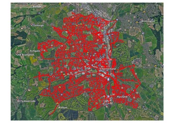
Done!